|
Kilburn is an area in North West London, in the London Boroughs of Camden, Brent and the City of Westminster. Kilburn High Road railway station lies 3.5 miles (5.6 km) north-west of Charing Cross.
Kilburn developed from a linear hamlet that grew up on ancient Watling Street (the modern A5 Road), the hamlet took its name from Kilburn Priory, which was built on the banks of Kilburn Brook. Watling Street forms the contemporary boundary between the boroughs of Brent and Camden.
The area has London's highest Irish population, as well as a sizable Afro-Caribbean population, and was once home to the black civil rights leader Billy Strachan.
Kilburn has never been an administrative unit and has therefore never had any formally defined boundaries. The area, which took its name from a nearby watercourse and eponymous priory, developed from a linear hamlet along Watling Street (here called Kilburn High Road) which was the boundary of the Ancient parishes of Willesden - to the west of Watling Street and now part of Brent, and Hampstead to the east (now part of Camden). These parishes subsequently became a Municipal and a Metropolitan Borough respectively (based on the same boundaries), before merging with neighbouring areas in 1965 to form modern London Boroughs of which they are now part.
If Kilburn is taken to extend into the City of Westminster then the historic districts it overlaps are Paddington, to the west of Watling Street, and Marylebone to the east of it. Both of these areas became part of the City of Westminster in 1965. The electoral wards of Kilburn (Camden) and Kilburn (Brent) cover some of the area. Much of the area is in the NW6 postcode area, and by some interpretations the area extends into W9; however, these do not define Kilburn; postcode areas were never intended to delineate districts, and Kilburn (like many London districts) overlaps with others, some which have a history of formal definition (e.g. Willesden, Hampstead) and others which do not (e.g. Brondesbury in Willesden).
Kilburn High Road originated as an ancient trackway, part of a route between the Brittonic settlements now known as Canterbury and St Albans. Under Roman rule, the route was paved. In Anglo-Saxon times the road became known as Watling Street.
Kilburn Priory was built on the banks of a stream variously recorded as Cuneburna, Kelebourne and Cyebourne (in the latter source most other places with the phonetic sound were rendered in writing Cy such as Cynestone (Kingston)). The stream flowed from Hampstead through this parish, then through Paddington (specifically through areas that became "Westbourne", "Bayswater" and Hyde Park), South Kensington, and the narrow east part of Chelsea into the Thames. The first two names perhaps imply meanings of "King's Bourne" and "Cattle Bourne". The word Bourne is the southern variant of burn (any small "river"), as still commonly used in the technical term, winterbourne - a watercourse which tends to dry up in dry periods. The river is known today as the Westbourne. From the 1850s many of its feeder ditches were diverted into combined sewers feeding away to the east; it was otherwise piped underground and became one of London's underground rivers.
The name "Kilburn" was first recorded in 1134 as Cuneburna, referring to the priory which had been built on the site of the cell of a hermit known as Godwyn.[9] Godwyn had built his hermitage by the Kilburn river during the reign (1100-1135) of Henry I, and both his hermitage and the priory took their name from the river.
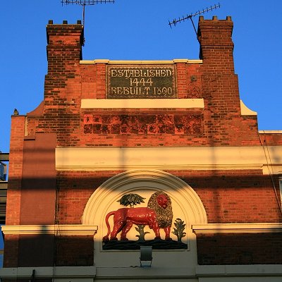
Kilburn Priory was a small community of nuns, probably Augustinian canonesses. It was founded in 1134 at the Kilburn river crossing on Watling Street (the modern-day junction of Kilburn High Road and Belsize Road). Kilburn Priory's position on Watling Street meant that it became a popular resting point for pilgrims heading for the shrines at St Albans and Willesden. Henry VIII's administration dissolved the priory in 1536-37, and nothing remains of it today[11] except the name of Abbey Road (in nearby St John's Wood), named from a track which once led to the priory. The priory lands included a mansion and a hostium (a guesthouse), which may have been the origin of the Red Lion pub, thought to have been founded in 1444. Opposite, the Bell Inn opened around 1600, on the site of the old mansion.
The fashion for taking "medicinal waters" in the 18th century came to Kilburn when a well of chalybeate waters (water impregnated with iron) was discovered near the Bell Inn in 1714. In an attempt to compete with the nearby Hampstead Well, gardens and a "great room" opened to promote the well, and its waters were promoted in journals of the day as cure for "stomach ailments": "Kilburn Wells, near Paddington. The waters are now in the utmost perfection; the gardens enlarged and greatly improved; the house and offices re-painted and beautified in the most elegant manner. The whole is now open for the reception of the public, the great room being particularly adapted to the use and amusement of the politest companies. Fit either for music, dancing, or entertainments. This happy spot is equally celebrated for its rural situation, extensive prospects, and the acknowledged efficacy of its waters; is most delightfully situated on the site of the once famous Abbey of Kilburn, on the Edgware Road, at an easy distance, being but a morning's walk, from the metropolis, two miles from Oxford Street; the footway from the Mary-bone across the fields still nearer. A plentiful larder is always provided, together with the best of wines and other liquors. Breakfasting and hot loaves. A printed account of the waters, as drawn up by an eminent physician, is given gratis at the Wells." — The Public Advertiser, July 17, 1773.
In the 19th century the wells declined, but the Kilburn Wells remained popular as a tea garden. The Bell was demolished and rebuilt in 1863, the building which stands there today.[clarification needed] The Kilburn stretch of Watling Street, now called Edgware Road and Kilburn High Road, was gradually built up with inns and farm houses. Despite the discovery of the medicinal well in 1714, and the construction of gardens and a fine room to exploit the water, Kilburn did not attract any significant building until around 1819 in the area near St John's Wood. These 19th century developments mark the emergence of the nucleated roadside hamlet from which the modern district of Kilburn developed.
Between 1839 and 1856, the newsagent and future First Lord of the Admiralty William Henry Smith lived in a house to the west of Kilburn High Road. Solomon Barnett developed much of the area in the last decades of the 19th century, naming many of the streets after places in the West Country (e.g. Torbay) or after popular poets of the day (e.g. Tennyson) in honour of his wife.
The funeral of Michael Gaughan, an Irish republican and a member of the Provisional Irish Republican Army (IRA) who died from hunger strike in 1974, took place on 8 June 1974. Over 3,000 mourners lined the streets of Kilburn and marched behind his coffin - which was flanked by an IRA "honour guard" - to a Requiem Mass held in the Church of the Sacred Heart of Jesus. The Biddy Mulligan's pub on High Road, which was popular among the local Irish population, was bombed in retaliation on 21 December 1975 by the Ulster Defence Association (UDA), an Ulster loyalist group during the Troubles of Northern Ireland. Although there were 90 people in the pub at the time of the bomb, there were few injuries. It was the only loyalist bombing in London during the conflict in Northern Ireland.
|