
Like us on Facebook
PLACE NAMES


|
|
Longford
|
| |
Longford is a suburban village in the London Borough of Hillingdon, England. It is immediately north-west of London Heathrow Airport, which is in the same borough. It is the westernmost settlement in Greater London, very close to the borders of both Berkshire and Surrey.
It was formerly part of Harmondsworth by tithes, land tax, vestry and still by Church of England parish. As it has never had a church it can also be considered a hamlet. Until 1965 it was in the historic county of Middlesex.
Longford is 16 miles (25.5 km) west of Charing Cross and within the M25 motorway which marks its western boundary with Colnbrook, Berkshire. The village is currently earmarked for demolition as a result of the expansion of nearby Heathrow Airport.
The name Longford derives from the two words "long" and "ford", after the wide ford across the Colne which is where the old Bath Road crosses it, a middle ditch, and the Wraysbury River, carrying on west from the village street. Its old country residents pronounced its name as "Long Ford" with both syllables stressed.
The settlement developed by this multi-channel ford of the River Colne and its distributaries, which presented numerous obstacles for travellers to and from the west of the edge of Middlesex, on the old Bath Road west out of London. Longford may be founded on a small Saxon settlement dating from the 5th to 7th century AD. Historic buildings survive from the medieval and immediate post-medieval periods. Limited evidence survives of Roman occupation, though archaeological excavations have revealed two brooches of Roman date.
Longford, the only medieval settlement to grow up along the Bath Road in Middlesex, had 30 inhabited buildings in 1337. An important part of the parish economy, aside from its four manor houses, 48 houses were on Moor and Sheep Lanes in Harmondsworth.
In 1586 land on either side of the river was charged with the upkeep of Mad Bridge, which carried the Bath Road across the river. During the 18th and early 19th centuries this bridge was maintained by the Colnbrook turnpike trustees, who presumably erected in 1834 the bridge with cast-iron parapets which now stands.
Rocque's map of 1754, shows clearly the settlement pattern: at Longford, Harmondsworth, Sipson there were small compact groups of houses, and a straggling group at Heathrow. At Longford they lined both sides of the Bath Road from the east bank of the Longford River up to and across the Duke of Northumberland's River.
The uncultivated area west of the rivers was to the north known as Harmondsworth moors, south of the Bath Road the area between the Colne and the Longford rivers was meadowland and, between the Longford and the Duke's rivers, arable.
Parliament's Act of common land inclosure (privatisation) came to Harmondsworth parish in 1819; in it Harmondsworth's three open fields and Harmondsworth Moor and a big tract to and around Heathrow (part of Hounslow Heath) were divided among the local residents. During this Enclosure two bad bends of the Bath Road in Longford were straightened.
By 1839 Longford and Harmondsworth and Sipson had a shop serving the whole parish.
In 1929 the Longford and Colnbrook by-pass was built.
In 1930 the Road Research Laboratory on the Colnbrook by-pass opened. In the same year the Fairey Aviation Company opened an airfield, the Great West Aerodrome, southeast of Heathrow village.
About 1930 a brickworks was set up east of the junction of Cain's Lane and Heathrow Road in Heathrow. Later the quarry's main purpose changed to excavating sand and gravel. The quarry company went bankrupt in 1943; after 1944 the airport obliterated the quarry along with every trace of Heathrow village.
Middlesex County Council opened a large sewage sludge settlement works west of Perry Oaks farm; in the 1990s it was removed and Heathrow Airport's Terminal 5 is there now.
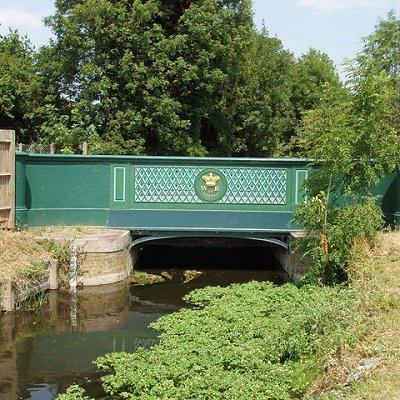
In 1648 the first bridge across the then-new Longford River was demolished. This had been replaced by 1675. In the 19th century, when it was called Stone Bridge, the Crown, not a local authority, was responsible for its upkeep and by 1960 it had been renamed King's Bridge.
|
 Feel free to Email me any additions or corrections Feel free to Email me any additions or corrections
LINKS AVAILABLE TO YOUR SITE
| |


