
Like us on Facebook
PLACE NAMES


|
|
Cranford
|
| |
Cranford is a suburban area straddling the London Boroughs of Hillingdon and Hounslow. It is located 12.5 miles (20 km) west of Charing Cross and immediately east of Heathrow Airport, from which it is separated by the River Crane. A village till the mid-20th century, Cranford was developed with the building of major roads in its area.
Its name came from Anglo-Saxon cran-ford = "ford of cranes" as at the time the word heron was not used for that bird and it covered an almost north–south rectangle lengthwise of 737 acres (2.98 km²).
Before the Norman Conquest, the village was a small Saxon settlement in all senses completely surrounded by its open fields abutting the north of Hounslow Heath and was in Elthorne Hundred for troop-mustering and taxation purposes. The Domesday Book of 1086 records the manor of Cranford being given to a Norman baron, William Fitz Ansulf. By the 13th century, the main area of Cranford Park and House, the High Street and Bath Road had been given to the Knights Templar (followed by the knights of St John of Jerusalem) as Cranforde St John. The rest, Cranford le Mote, included the manor house and stretched in a narrow taper to the north of the present M4. The manors were reunited by purchase by Sir Roger Aston, an official to the King, 64 years after the Dissolution of the Monasteries and were bought by Sir Thomas Berkeley's widow Elizabeth in 1618. These stayed in the Berkeley family, who granted smallholdings over this period, until selling the house and Cranford Park to Hayes and Harlington Urban District Council in 1932, before being sold again to Middlesex County Council in 1935. The Park was then leased back to Hayes and Harlington Urban District Council who jointly administered it with Heston and Isleworth Borough Council, to whom Cranford had been transferred in 1934. For the history of the south of the present ward this was part of Hounslow Heath within Heston parish.
There was a ford to the north of the church on Watersplash Lane, but the main crossing was where the bridge replaced it on the Bath Road. The river was widened, probably in the 18th century, on either side of the Church Road to form two ornamental lakes. By 1820, there were at least four large ponds, three of which lay in the village on the edge of the common on the Southall Road. The fourth lay immediately east of the moat. By 1958, these had all been drained.
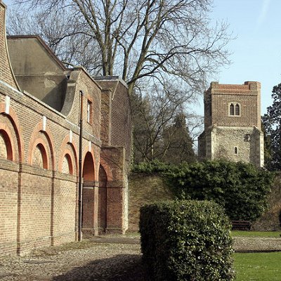
The village still has some distinguished houses, including Stansfield House, a 17th--century listed building. Cranford also has one of only two remaining "lock-ups" in the Metropolitan Police area, this one built in 1838 to hold drunks and vagrants overnight, before finding use as a mortuary for the parish council. The wider borough states that Cranford "was described for centuries as one of the smallest and prettiest villages in Middlesex".
The Berkeley family also gave their name to Berkeley Parade, where there are now many shops, largely convenience or regular services, which were built on remaining common land open fields on the south of the Bath Road in the 1930s - the "chateau-type" buildings with little slated turrets were branded "ingenious architectural fun" in the journal Architectural Review in 1939. The Parkway was built in 1959 as a bypass and this became a link to the 1960-1964-built M4 motorway cutting through the north end of the area. Both had considerable impact on the area. Much of Heston was developed in the early 1930s and this extended westward towards Cranford later, which also became developed to the west and south of the Parkway. The Parkway has cut Cranford in two, severing the high street into two sections, and along many sections there is not even a pavement for pedestrians though instead a green footpath alongside an inter-London trunk route.
|
 Feel free to Email me any additions or corrections Feel free to Email me any additions or corrections
LINKS AVAILABLE TO YOUR SITE
| |


