
Like us on Facebook
PLACE NAMES


|
|
South Croydon
|
|
|
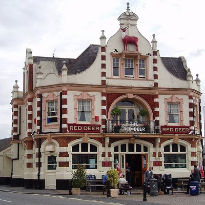
South Croydon in south London is the area surrounding the valley south of central Croydon and running as far south as the former Red Deer public house on the Brighton Road. It is bounded by Waddon to the West and Selsdon and Sanderstead to the East. It is part of the South Croydon (CR2) post town and in the London Borough of Croydon.
The area was developed in the 19th century out of land lying in two ancient manors, Croham and Haling. The names of these can still be seen in the area today, and the locations of the manor houses can be found in the Croham Manor Road conservation area and in Whitgift School. Much of the land of South Croydon has been associated through the years with the Whitgift Foundation whose charitable work has benefited and influenced Croydon since its foundation in 1596.
The placename Croydon is recorded as early as 809 and is listed in the 1086 Domesday Book, where it is described as the land held in Demesne by Lanfranc, the Archbishop of Canterbury in Waletone (that is Wallington) hundred. In the medieval and early modern periods the town limits, within which the inhabitants enjoyed certain privileges of self-government and tenure, were defined by boundary markers known as the "four crosses": beyond these markers, the more restrictive rules of manorial tenure applied. The southernmost marker, Hern Cross, was cut in an elm tree at the southern end of the High Street. Plaques marking the sites of the crosses (including that of Hern Cross, on the former Blacksmiths Arms, now the Corner House, at the corner of Coombe Road and South End) were erected by the Croydon Rotary Clubs in 1977.
South Croydon as a distinct area south of Hern Cross is found much later, in the 19th century, when the area was developed as a residential suburb in land lying within the ancient manors of Croham and Haling. Croham Manor and the Croham area were purchased in 1601 by the Whitgift Foundation. Croham was one of four manors in the parish of Sanderstead, and included surrounding farm land and Croham Hurst. The Whitgift Foundation was and remains a charity providing care for the elderly and education for young people in Croydon. Land in South Croydon supported the foundation's work elsewhere in Croydon but in 1931 Whitgift School moved to its current South Croydon site, Haling Park. The manor of Haling lay in the parish of Croydon, and covered 400 acres. It was notable in Tudor times as the home to Lord Howard of Effingham, the Lord High Admiral of the Fleet sent against the Spanish Armada, and was host to a succession of royalty and notable visits. The estate was sold for building in 1850[9]: 452 and Whitgift school now occupies manor house buildings dating to the 17th century.
With the advent of stage coaches, a London to Brighton route was established, with horses being changed in Croydon. Stables were built in South Croydon at Crunden Place, near the Red Deer inn on the Brighton Road; these were used by the coaching business. These stables would later become the location of South Croydon bus garage, which now opens on to Crunden Road as well as the Brighton Road.
Croham Hurst was bought as an open space for local people from the Whitgift Foundation by Croydon Corporation in 1901, an area of 34 hectares. This was after three years of local campaigning by residents against development of the area by the Whitgift Foundation.
Landmarks include:
- Croham Hurst round barrow (marker stone)
- 46 South End and historical tramlines
- Red Deer Inn and Public House
- Emmanuel Church was opened in 1897. The church was funded by the Watney Sisters whose family ran the eponymous brewery firm.
- St Augustine's Church. This flint walled church was designed by John Oldrid Scott and built in 1884.
- St Peter's Church is a Grade II listed building. It was designed by George Gilbert Scott and dedicated in 1851.
- Croham Hurst is a 33.6 hectare (83.02 acre) biological Site of Special Scientific Interest (SSSI) and a Site of Metropolitan Importance for Nature Conservation. Its SSSI designation is due to its importance for nature conservation, but it is also a Regionally Important Geological Site. The site is a steep hill, which is ancient woodland, although there are few very old trees because until the railways made cheap coal available, the timber was used for fuel. On the lower slopes there is a diverse community of plants dominated by oak and hazel on rich soils overlying chalk. Further up the trees are mainly beech on Thanet Sands, and towards the top the main trees are oak and birch on the acidic Blackheath pebble beds. The Thanet Sands have eroded, but the Blackheath beds are bound by a natural cement, and this has resisted erosion to make a natural cap to the hill. The top is mainly bare of trees, with rounded pebbles made when the area was the base of shallow seas in the Eocene epoch around 50 million years ago. The sparse vegetation at the top is mainly wavy hair-grass, heather and bilberry.
- The Croham Manor Road Conservation Area lies in South Croydon, running from the junction with the Selsdon Road along the West side of Croham Hurst. The area is notable for its distinctive and planned 1930s architecture.
- South Croydon bus garage is located on the corner of Brighton and Napier Roads. The site was previously the location of Crunden Place stables that were used by coaching companies. Built by the London General Omnibus Company, the garage was handed over to Thomas Tilling upon opening on 23 January 1916 as part of an agreement between the two operators. In 1933 it passed with the business to the London Passenger Transport Board and each subsequent operator of the London Transport brand. The garage underwent roof reconstruction in the early 1930s to allow double decker buses to use it. The building was destroyed in May 1941 in an air raid that killed seven staff. The reconstruction was not completed until the mid-1950s. As part of the privatisation of London bus services, in January 1995 it was sold to Arriva London with the South London business unit as their Croydon (TC) garage. Arriva continue to use it to operate services under contract to Transport for London.
- 46 South End is Croydon's oldest surviving shop. The building is Grade II listed, dating back to the 17th century. It retains its original timber framing and the front has distinctive and attractive elevations. The rear of the building is partly of modern construction. Since 1985 it has been home to Just Flutes, a music shop.
- The Red Deer. This Victorian era inn was open by 1851 in a prominent location on the Brighton Road. It acted as a local landmark as a tram and train terminus and also gave its name to bus stops. The inn and pub were closed in 2013.
- Although not the original hotel, the Swan and Sugarloaf is a landmark in South Croydon that gave its name to the surrounding area, now known as The Swan. The hotel stands at the junction of the Brighton and Selsdon Roads and the original hotel began as a farm house. It was part of the property that Archbishop John Whitgift devoted to his hospital in the 16th century. Much of South Croydon was such Whitgift land. The building was decorated with the Archbishop's arms, which were a cone or sugarloaf hat and a crook, which resembled in shape the curve of a swan's neck. It was this resemblance that led to local people misunderstanding the heraldic symbols and the farmstead became known as the Swan and Sugarloaf, a name that was retained when it was later licensed as a public house and hotel. The Swan and Sugar Loaf no longer operates as an inn, and was converted to a branch of the Tesco Express Minimarket in 2012; despite local pressures against the conversion to preserve locally owned shops in the area. Despite t
- his, the area is still known locally as "Swan and Sugar Loaf" and it still lends its name to the nearby bus stops.
- Whitgift School was founded in 1596 by the Archbishop of Canterbury John Whitgift and opened in 1600 as part of the Whitgift Foundation, which had the aim of building a hospital and school in Croydon for the "poor, needy and impotent people" from the parishes of Croydon and Lambeth. Originally located in North End, Croydon in 1931 it moved to its current site, Haling Park, which was once home to Lord Howard of Effingham, the Lord High Admiral of the Fleet sent against the Spanish Armada.
|
 Feel free to Email me any additions or corrections Feel free to Email me any additions or corrections
LINKS AVAILABLE TO YOUR SITE
| |


