|
Tadcaster is a market town and civil parish in North Yorkshire, England, 15 miles (24 km) north-east of Leeds and 10 miles (16 km) south-west of York.
Its historical importance from Roman times onward was largely as the lowest road crossing-point on the River Wharfe until the construction of the A64 Tadcaster by-pass some 660 yards (600 m) to the south, in 1978. There are two rail crossings downstream of the town before the Wharfe joins the River Ouse near Cawood. Thanks to its position on the banks of the River Wharfe parts of the town adjacent to the bridge are prone to flooding.
The town was part of the West Riding of Yorkshire until 1974, but is now part of North Yorkshire. Tadcaster is twinned with Saint-Chély-d'Apcher in France.
The Romans built a settlement and named it Calcaria from the Latin word for lime, reflecting the importance of the area's limestone geology as a natural resource for quarrying, an industry which continues and has contributed to many notable buildings including York Minster. Calcaria was an important staging post that grew at the crossing of the River Wharfe on the road to Eboracum (York).
The suffix of the Anglo-Saxon name Tadcaster is derived from the borrowed Latin word castra meaning 'military camp' (the plural of castrum, fort), although the Angles and Saxons used the term for any walled Roman settlement. Tadcaster is first mentioned in the Anglo-Saxon Chronicle, where it appears as Táda, referring to the place where King Harold assembled his army and fleet before entering York and proceeding onwards to the Battle of Stamford Bridge in 1066. The place-name probably means 'Tata's fort' after an unknown Anglo-Saxon landowner.
The town is mentioned in the Domesday Book of 1086 as "Tatecastre". The record reads: "Two Manors. In Tatecastre, Dunstan and Turchil had eight carucates of land for geld, where four ploughs may be. Now, William de Parci has three ploughs and 19 villanes and 11 bordars having four ploughs, and two mills of ten shillings (annual value). Sixteen acres of meadow are there. The whole manors, five quaranteens in length, and five in breadth. In King Edward's time they were worth forty shillings; now one hundred shillings.
In the 11th century William de Percy established a motte-and-bailey fortress re-using Roman stone. The earthwork remains of this castle, including the motte (known as Castle Hill) can still be seen adjacent to the parish church and bridge. The castle was abandoned in the early-12th century and was briefly re-fortified with cannon emplacements during the Civil War. The street plan south of the site reflects the shape of the former bailey.
Before 1186, Matilda de Percy, the wife of William de Beaumont, 3rd Earl of Warwick gave the hospital here to Sawley Abbey (now in Lancashire, previously in West Yorkshire).
The original river-crossing was probably a ford near the current bridge, followed by a wooden bridge. Around 1240, the first stone bridge was constructed, possibly from stone reclaimed from the castle. The current bridge was constructed on the foundations of the original (1699), although it has been substantially modified in 1736 and 1753. Then in 1791, John Carr built another bridge immediately above the 1699 bridge effectively extending it to twice the width it was before. Historically, the Wharfe marked the boundary between the West Riding and the Ainsty of York.
During the English Civil War, on the morning of Tuesday 7 December 1642 the Battle of Tadcaster, a skirmish, between Sir Thomas Fairfax's Parliamentarian forces and Sir Thomas Glemham's Royalist army took place on and around Tadcaster Bridge.
A market has been held since 1270, when Henry de Percy obtained a royal charter from King Henry III to hold "a market and fair at his manor of Tadcaster". The ancient market place is at the junction of Kirkgate and Bridge Street. A stone base, believed to have been part of the original market cross, stood on Westgate where the Tadcaster War Memorial now stands. The present-day market is held on Thursdays in the car park of Tadcaster Social Club on St Josephs Street.
Landmarks include:
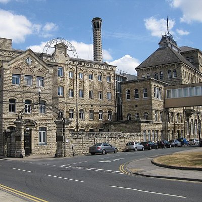
Breweries: The colossal Tadcaster (John Smith's) Brewery (1883, with later additions), a notable example of Victorian industrial architecture, stands on the site of John Smith's earlier brewery at the southern end of the High Street. The tall stone chimney and ornate wrought-iron atrium are prominent features and are listed (protected) structures.
Adjacent to these, across the narrow New Street, are the more modest Georgian headquarters of Samuel Smith's Brewery, with a handsome frontage on the High Street (formerly the Londesborough Arms and the Old Town Hall), and the brewery tap, The Angel and White Horse.
The Ark: The oldest building in active use in the town besides the parish church and Old Vicarage, is the half-timbered building on Kirkgate known as The Ark, built in the late 15th century, although it has been enlarged and altered many times since. Two carved heads on its front are thought to represent Noah and his wife, hence the name. The Ark has been a meeting place, a post office, an inn, a butcher's shop, a private house and a museum; it is currently the Town Council offices. In the 17th century it was known as Morley Hall, and was licensed for Presbyterian meetings. Some of the so-called Pilgrim Fathers are reputed to have planned their voyage to America in the building; an exact replica exists in Ohio, US.
Viaduct: The eleven-arch Tadcaster railway viaduct is 1/4-mile (400 m) above the Wharfe bridge; it was built as part of a projected York and North Midland Railway (Leeds Extension) line from Leeds to York. Construction of the line was authorised in 1846, and much of the northern section including the viaduct had been completed when the collapse of railway investment in 1849 led to its abandonment. Between 1883 and 1959 the viaduct carried a short branchline servicing a corn mill on the east side of the River Wharfe (Mill Lane area). The viaduct is a Grade II listed building owned by Tadcaster Town Council.
Bridge: The current bridge dates back to the early 1700s and was built, according to Pevsner, using stone from the ruined Castle. It was widened in the C19th. It is the main transport route connecting the town centre, which is divided by the river, and one of the town's two road crossings, the other being the A64 bypass bridge. The bridge partially collapsed on 29 December 2015, following flooding. The collapse fractured a gas main and prompted the evacuation of hundreds of residents and divided the town in two. In early 2016, Historic England carried out an assessment of the significance of the Grade-II listed bridge to inform its restoration. The bridge was then repaired and widened, and re-opened to traffic on 3 February 2017. The area around the bridge, including the north end of the High Street, the houses in Wharfe Terrace, the Bus Station and the Tadcaster Medical Centre, was flooded once again in February 2022.
Tadcaster Mere: To the south east of the town centre, towards the village of Oxton, lies Tadcaster Mere. Designated a Site of Special Scientific Interest (SSSI) in 1987, the mere is at the centre of a former lake basin that extended over an area of about 740 acres (3 km²). It was formed during the most recent or Devensian ice age, which ended 10,000 years ago, when Tadcaster was at the southernmost limit of glaciation, by the long, low embankment of debris known as the Escrick Moraine, which is composed of debris left behind by the Vale of York Glacier. The mere is a site of current palaeontological interest, as it is believed to be the site of the earliest discovery of the plesiosaur; while unproven, the skeletal fragments found in Tadcaster match the age of those found elsewhere.
Scientific analysis of the mere, in particular sedimentary pollen studies, provides insight into the geological history and makeup of the local environment and allows accurate dating of events before, during and after the Devensian ice age.
|