Like us on Facebook
PLACE NAMES


|
|
Kettlewell
|
| |
|
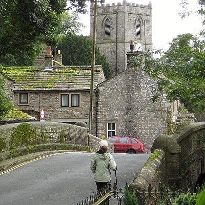
Kettlewell is a village in Upper Wharfedale, North Yorkshire, England. It lies 6 miles (10 km) north of Grassington, at the point where Wharfedale is joined by a minor road (Cam Gill Road) which leads north-east from the village over Park Rash Pass to Coverdale. Great Whernside rises to the east. The population of the civil parish (Kettlewell with Starbotton) was 322 at the 2011 census, with an estimated population of 340 in 2015. The population was recorded as being at 321 according to the United Kingdom 2021 census.
Until 1974 it was part of the West Riding of Yorkshire. From 1974 to 2023 it was part of the Craven District, it is now administered by the unitary North Yorkshire Council.
It is believed that the name Kettlewell is Anglo Saxon and comes from Chetelewelle which means a bubbling spring or stream. Signs of the farming methods of Romano-British and early medieval agriculture can still be seen in terraced fields to the north and the south of the village.
In the 13th century, a Thursday market was established in Kettlewell, which became a thriving community. The market mostly sold corn, and was held in the square opposite The King's Head Inn. A watermill was built on the River Wharfe in the 13th century to grind corn. Textiles (and, in the late 18th and early 19th centuries, lead mining) revitalised the village and Kettlewell's appearance today derives much from its past 200 years. The remains of the smelting-mill, used from 1700 to 1880, can be seen near the meeting of Cam Gill and Dowber Gill Becks half a mile above the village.
In 1686 Kettlewell and Starbotton were almost destroyed in a flood. Heavy rainfall descended on the adjacent hills and cascaded down into the village demolishing several houses and causing the residents to flee.
On 5 July 2014, the Tour de France Stage 1 from Leeds to Harrogate passed through the village.
Kettlewell is situated in Upper Wharfedale around two miles upstream of where it converges with Littondale. The B6160 crosses the River Wharfe by a stone bridge. The village is situated just west of the confluence of Dowber Gill Beck and Cam Gill Beck, which join to form Kettlewell Beck flowing through the village to join the River Wharfe. There are many small bridges across Kettlewell Beck which dissect the village.
|
 Feel free to Email me any additions or corrections
LINKS AVAILABLE TO YOUR SITE
| |


